York Region is adding lanes, sidewalks and cycle tracks along the Vaughan–Richmond Hill boundary. The project may improve how the corridor works—but taxpayers should be told what lasting return they are receiving for the money and infrastructure obligations they will inherit.
By Editorial Board
Anyone who regularly travels on Bathurst Street between Highway 7 and Major Mackenzie Drive understands why the road has become a target for major investment.
At busy times, traffic backs up at intersections, buses get caught in the same congestion as cars, and short trips can become frustratingly unpredictable. Meanwhile, Vaughan, Richmond Hill and the rest of York Region are expected to continue growing. The Region’s official plan anticipates approximately 2.06 million residents and 989,200 jobs by 2051.
York Region’s response is already under construction.
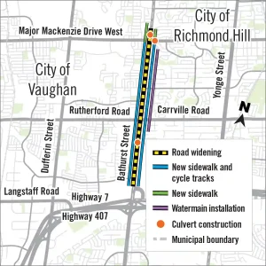
Bathurst is being widened from four lanes to six along approximately six kilometres of the Vaughan–Richmond Hill boundary. The two additional lanes are intended for transit and High Occupancy Vehicles. The project also includes new sidewalks and cycle tracks, intersection and lighting upgrades, storm sewers, culvert work, landscaping and a Richmond Hill watermain. Construction began in spring 2026 and is expected to continue until late 2028.
This is not simply a conventional widening in which two general traffic lanes are added and everyone is promised a faster drive. The transit, walking and cycling components could make Bathurst a more complete transportation corridor.
But before debating induced demand, tree removal or the precise design of a cycle track, there is a more fundamental question:
What are taxpayers buying, and how long will the benefits last?
The strongest argument for the project
Doing nothing is not a serious long-term strategy.
Bathurst is a major regional road connecting neighbourhoods, schools, commercial areas and community facilities. It carries local trips and longer journeys toward Highway 7, Highway 407, Rutherford Road and Major Mackenzie Drive.
The road also requires more than added traffic capacity. Underground utilities, drainage systems and culverts need attention. Sidewalk and cycling gaps remain. Intersections and lighting can be modernized while the corridor is already under construction.
Completing those projects together may be less disruptive and more economical than repeatedly excavating the road for separate work.
Most importantly, York Region says the two new lanes will be Transit/HOV lanes, intended to provide more travel choices rather than simply accommodate more single-occupant vehicles.
That makes the project more defensible than an ordinary road widening.
It does not, however, automatically make it a good investment.
What are taxpayers actually buying?
Public infrastructure should not be evaluated only by whether people want it or whether it makes travel temporarily more convenient.
The proper question is whether the lasting public value exceeds the complete public cost.
That calculation has several parts.
Start with the full price
The cost of Bathurst is not limited to paving two additional lanes.
It includes engineering and project management, utility relocation, drainage and culvert work, intersection reconstruction, lighting, property requirements, sidewalks, cycle tracks, landscaping and the Richmond Hill watermain.
After completion, taxpayers will also assume responsibility for maintaining a larger corridor. More pavement must be cleared, repaired, resurfaced and eventually reconstructed. Sidewalks and cycle tracks need winter maintenance. Signals, drainage infrastructure, landscaping and lighting create continuing operating and replacement costs.
York Region’s main Bathurst project pages describe the scope and construction schedule but do not provide residents with a clear, updated, all-in project cost. That makes it difficult to assess the project’s financial return from the information currently presented to the public.
The Region should publish not only the latest capital cost but also an estimate of the corridor’s additional lifecycle obligations.
The Strong Towns question is not merely whether York Region can afford to build Bathurst today.
It is whether the homes, businesses and economic activity supported by this investment can help sustain its maintenance and eventual replacement for generations.
Measure transportation value in people, not cars
A transportation investment should be judged by the access and mobility it creates.
That means measuring more than the number of vehicles passing a particular point.
York Region should track:
- How many people the corridor moves during peak periods
- Bus travel times and schedule reliability
- Average door-to-door travel times
- Access to jobs, schools, shops and services
- The number and severity of collisions
- How long any reduction in congestion lasts
A lane occupied by a continuous line of cars may appear highly productive. But a lane carrying fewer vehicles could move many more people if it contains frequent, well-used buses.
That distinction is essential on Bathurst. The two new lanes can be justified only if their transit and carpool function produces a meaningful increase in people-moving capacity, not merely a larger road carrying more vehicles.
Ask what economic value the corridor supports
Roads do not create their return in isolation. Their financial productivity also depends on the land around them.
A costly six-lane arterial surrounded primarily by parking lots, low-density subdivisions and widely separated destinations may carry a great deal of traffic while producing a relatively weak return on the public infrastructure serving it.
By contrast, a corridor with housing, shops, services and employment close to reliable transit can support more economic activity and municipal revenue within a smaller area.
Vaughan and Richmond Hill therefore have an important role even though Bathurst is a Regional road.
If the cities retain land-use patterns in which nearly every activity requires a separate car trip, the widened corridor will continue generating more traffic and more pressure for expansion.
If they permit a reasonable concentration of homes and services near the corridor, improve local street connections and make transit stops genuinely accessible, the same infrastructure can serve more people and support a stronger tax base.
The financial return on Bathurst will be determined partly by what happens beside the road, not just what happens on it.
Compare it with what else the money could accomplish
Every infrastructure decision carries an opportunity cost.
The alternative to this project is not necessarily leaving Bathurst exactly as it is. The same public resources—or a portion of them—could potentially support some combination of:
- More frequent bus service
- Transit-signal priority
- Queue-jump lanes at congested intersections
- Targeted intersection reconstruction
- Safer pedestrian crossings
- Better access to bus stops
- Connected cycling and local street networks
- Maintenance of other existing infrastructure
Some of those investments may be included in or complement the present project. Others may not replace the need for reconstruction.
But taxpayers should still be shown why the selected package produces a stronger and more lasting return than the realistic alternatives.
Building more physical space for buses while failing to fund useful bus service would be a poor trade. Likewise, building cycle tracks without safe connections at major intersections would create infrastructure whose practical value falls short of its construction cost.
Identify who receives the benefit
A project can produce an overall benefit while distributing its gains and costs unevenly.
Through-drivers may save time. Transit passengers may receive a faster and more reliable trip. Developers and property owners may benefit from improved access. Local businesses may gain customers—or lose visibility and access during prolonged construction.
Nearby residents may receive better sidewalks and cycling connections while also experiencing noise, tree loss, wider crossings and additional traffic.
A complete ROI analysis should identify these groups rather than treating “the public” as though everyone experiences the project in the same way.
The Region should be able to explain not merely that Bathurst will improve, but who will benefit, by how much, and for how long.
Induced demand is a risk to the return
Once the project is understood as an investment, induced demand becomes more than an abstract transportation debate.
It becomes a financial risk.
Induced demand does not mean that vehicles mysteriously materialize when a lane opens. It means people respond when driving becomes faster or more convenient.
Drivers who previously avoided Bathurst may return. Some may travel during peak periods instead of adjusting their schedules. Households may choose driving over transit. People may make additional trips or feel comfortable living farther from their regular destinations.
Over time, those individual decisions consume part of the new capacity.
Economists Gilles Duranton and Matthew Turner found a close relationship between increased urban road capacity and increased vehicle travel. Their research concluded that adding road capacity generally does not produce a lasting reduction in congestion under the conditions they studied.
That finding does not prove that every road improvement is wasteful. Bathurst is not an expressway, and this project includes transit, walking, cycling and infrastructure renewal.
It does mean that York Region should not count temporary traffic relief as a permanent return.
Suppose the project initially saves a driver ten minutes but, several years later, additional traffic consumes most of that advantage. The benefit still existed, but its value was smaller and less durable than promised.
If taxpayers inherit decades of additional maintenance obligations in exchange for only a brief improvement in vehicle speeds, the return would be weak.
Can the Transit/HOV lanes change the equation?
Bathurst differs from a standard road widening because its new capacity is supposed to favour more efficient travel.
A bus carrying dozens of passengers uses far less road space per person than the same passengers travelling separately. Carpools can also carry more people without adding the same number of vehicles.
If buses and shared vehicles move reliably past congested general lanes, the project could increase mobility without producing the same degree of single-occupant vehicle growth.
But the designation alone is not enough.
The project’s success will depend on details that remain critical:
How many occupants will a vehicle need to use the lane? Will the restriction apply throughout the day or only during selected hours? How consistently will it be enforced? Will buses receive signal priority? Will YRT provide enough service to make the time advantage useful?
A resident does not experience transit as a lane on an engineering drawing.
The passenger experiences the walk to the stop, the wait for the bus, the reliability of the schedule, the speed of the journey and any necessary transfer.
Saving a bus several minutes on Bathurst would be valuable. But that benefit can be erased if the bus arrives too infrequently or if reaching the stop requires crossing an intimidating intersection.
There is also a longer-term political risk.
When motorists are sitting in congestion beside a Transit/HOV lane that appears relatively open, pressure may build to allow more vehicles into it. If the rules are weakened until the lanes function like ordinary traffic lanes, the project’s people-moving argument will largely disappear.
The reserved lanes must therefore remain reserved—and they must carry enough buses and passengers to make their value visible.
Do the walking and cycling improvements work in real life?
New sidewalks and cycle tracks are important additions. But their usefulness cannot be assessed by simply confirming that they appear on the project map.
For pedestrians, the major intersections will be the real test.
A six-lane arterial creates a longer crossing and exposes people to more turning movements. Safety depends on signal timing, refuge islands, turning radii, vehicle speeds and whether drivers are permitted to make fast turns across a pedestrian’s path.
Can a child, older resident or person using a mobility device comfortably complete the crossing during the signal cycle?
Can people reach bus stops from both sides of the road without taking a lengthy detour?
Will drivers encounter a design that requires them to slow down and look, or one that encourages them to move through the intersection as quickly as possible?
The planned cycle tracks should be tested in the same practical way.
Do they remain protected through intersections? How are conflicts with turning vehicles, driveways and bus stops handled? Do they connect safely with routes along Highway 7, Rutherford Road and Major Mackenzie Drive? Will they be maintained reliably in winter?
A six-kilometre facility that becomes dangerous at the largest intersections or ends without a useful connection may look complete on paper while remaining unsuitable for everyday transportation.
These details directly affect ROI. Infrastructure that residents do not feel safe using produces little transportation value, regardless of how attractive it appears in a rendering.
Environmental costs belong on the ledger
York Region says the project will include approximately 600 new trees, 2,800 shrubs and 8,500 perennials.
That replacement planting is significant, but young trees will take years to provide the shade, cooling, habitat and screening previously provided by mature trees.
A wider corridor also creates more hard surface to drain, clear, repair and eventually replace. These impacts may not determine whether the project should proceed, but they belong in the full accounting of costs and long-term obligations.
A view from Vaughan
For Vaughan resident and street safety advocate Eddy Aceti, the concern is whether widening Bathurst will produce enough lasting improvement to justify its effects on nearby communities.
“I live in Vaughan and for the last 15 years getting from Vaughan to Vaughan has always taken 45 minutes. Adding lanes to Bathurst will not change commute times, it will however make the surrounding areas suffer more noise pollution.
“… More lanes mean a longer crosswalk for pedestrians, and left turns become more dangerous. My understanding is that our typical two-lane road already has the capacity to move the volume of cars on the road, the bottle neck is at the intersections, so if you can’t increase the capacity at the intersections, adding a lane will not improve the commute times. The added lanes result in drivers weaving in and out more often, which is dangerous in and of itself.”
His comments point to two of the central tests facing the project: whether the additional lanes will produce a measurable improvement in travel times, and whether any benefit will outweigh the effects of a wider road on people living near or crossing Bathurst.
Why Richmond Hill should be watching
Bathurst is not a distant Vaughan project. It forms Richmond Hill’s western boundary and is used every day by Richmond Hill residents.
Its widening can influence traffic on Highway 7, Major Mackenzie Drive, Carrville Road and nearby neighbourhood streets.
It also offers a real-world test for future York Region projects, including other arterial widenings planned or underway across the Region. York’s current construction schedule includes several road expansions, including the widening of 16th Avenue from Leslie Street to Kennedy Road.
When another widening is proposed, Richmond Hill residents and councillors should be able to ask what taxpayers received from Bathurst.
Did buses become faster, more reliable and more frequent?
Did the Transit/HOV lanes carry substantially more people?
Did pedestrian and cyclist use increase?
Did serious collisions decline?
Did surrounding development make productive use of the investment?
Did the travel-time benefits remain five or ten years later?
Or did additional traffic consume the new capacity, leaving taxpayers responsible for a wider and more expensive corridor without lasting relief?
These are not anti-driver questions.
Drivers also lose when every additional home, customer, student and employee must contribute another vehicle to the same road system. Giving some people a practical alternative to driving can preserve road space for deliveries, emergency services, tradespeople, families and others who genuinely need it.
Publish the scorecard before declaring victory
York Region should establish a Bathurst performance scorecard using conditions before construction as the baseline.
It should report:
Cost: The final capital expenditure and projected lifecycle obligations.
Congestion: Peak travel times before construction and one, five and ten years after completion.
Transit: Bus frequency, speed, reliability and ridership.
Capacity: The number of people moved through major intersections—not just the number of vehicles.
Safety: Serious collisions and the experience of crossing the corridor.
Walking and cycling: Actual use, network connections and winter maintenance.
Economic productivity: New housing, businesses and tax-base growth supported by the corridor.
The Bathurst project should not be declared a success or failure before it is finished. Its Transit/HOV lanes, sidewalks, cycle tracks and infrastructure renewal give it more potential than a conventional road expansion.
But potential is not the same as return.
The real test will not be how quickly traffic moves immediately after construction ends. It will be whether, years later, Bathurst moves more people safely and reliably, supports valuable and productive places on both sides of the municipal boundary and delivers enough lasting public benefit to justify both its price and the infrastructure liability taxpayers will inherit.